Saturday, November 16, 2013

The warm hemisphere

I have been inspired to start the writing process again. This time inspired by the latest events. A couple of weeks ago I flew to east Asia for the first time for this amazing opportunity to present my work.  Another reason that I wanted to talk about this region is the recent devastation caused by Typhoon Haiyan, one of the strongest tropical cyclones ever recorded. At the time of this writing, Haiyan has claimed over 3600 lives. For information about how to help the victims of the typhoon, follow this link.

This sparked some curiosity to learn about the weather and climate of southeast Asia, Oceania (informally called here the Maritime Continent), and northern Australia. Some people have asked me: "Can a storm like Haiyan hit the U.S. coast?", and "How can storms like this form?". While the details of these questions can be left to tropical cyclone experts, there are some aspects about the region where Haiyan formed that are well known by many.  I will talk a little about these salient features through several blog posts. 

The area that encompasses the Maritime Continent, Southeast Asia, India  and Northern Australia is colloquially called the Indo-Pacific Warm Pool. This is a special region of the globe, where a combination of factors, including having the Maritime Continent near the equator, the nearly isolated Indian Ocean,  as well as even the planet's rotation combine to create some of the warmest sea surface temperatures (SSTs) in the world. Below is an animation of SST throughout the year. Notice how the warmest temperatures are in the Western Pacific Ocean throughout the year, with some wobbling north and south with changes in season.


Animation of climatological sea surface temperatures.

For these, and many other reasons, the Eastern Hemisphere is often described as the Warm Hemisphere (note that the western hemisphere tropics aren't cold,  they're  just not as warm as the Eastern Hemisphere tropics). Perhaps the signature of the warmer temperatures are even more obvious in a product called column integrated water vapor, which describes the total amount of water vapor in the troposphere.  Below is the column water vapor obtained from the ECMWF 40-year Reanalysis (ERA-40) Atlas, a nice open source tool that shows nice climatological plots. 

For boreal summer (June-August, JJA), it is clear that the Warm Pool is the region where the largest amounts of water vapor are.  This feature has profound impacts regionally,  in the form of the monsoon system, and globally. 

Column integrated water vapor JJA climatology from the ERA-40 Atlas
One of the many interesting results of all this is that this region has a lot more diabatic heating from condensation than anywhere else in the world, especially during the boreal summer months (JJA). Just see where the deepest shades of red are in the plot below. There are some regions of strong heating outside the Warm pool, corresponding to the Intertropical Convergence Zone, and a signature of the Gulf stream over the east coast of the US, which is also the signature of disturbances that curve to the northeast over that location.

Diabatic heating JJA climatology from the ERA-40 Atlas
This massive area of heating is crucial to the climate system, and an important contributor to the transport of heat towards higher (colder) latitudes. It also influnences significantly the circulation of the atmosphere by generating what we call stationary waves. Below is a map I made showing the difference of SST over the hemispheres by removing the mean SST from each latitude. This plot makes it clear where the warmest SSTs are found. Additionally, I show geopotential height anomalies, which can be thought as pressure. Over the tropical western Pacific, the atmosphere is "thicker", which means pressure is lower near the surface, but higher upper portions of the troposphere. It is the opposite over the eastern Pacific and the Atlantic.  Why so? I will cover the reasons why in a future blog entry.


Monday, July 15, 2013

Thoughts on long-distance cycling


It's been a while since I've written a blog post, and I think it's been long due that I write something that could be interesting yet fun to read. Anyways, this weekend I was doing the Seattle to Portland Bicycle Classic (STP), a two-day (for me) 200-mile ride from, well, Seattle to Portland. This is the first one of two double centuries I will be doing this summer (and one I signed up for on the last minute)
I am surprised that my body is not as devastated as I thought it would be, considering how tired I was every time I finished training.  Like any other ride, there are some neat tricks that'll make life easier for you, and some of them are related to the atmosphere. I will focus and those observations, and also describe the meteorological conditions during the two-day ride, which distracted me a lot! 


On the map below are the two routes for these year's double century rides. STP is to the left. A more interactive map can be found on this link.  Notice that is a pretty straightforward ride, with the only significant elevation gain occurring at abotu 40 miles into the ride.  The second climb happens at about 115 miles in. While these are only modest changes in elevation, they did have an effect on the temperature and wind I felt during the ride.


Overall, the weekend was beautiful, we had sunny weather and barely any clouds in the sky, which allowed for some amazing sunrises and sunsets, as well as a noticeable diurnal cycle.  Below is a meteogram from the rooftop of our Atmospheric Sciences Building. The red line was [roughly] the time I started biking on day 1 and 2, and the blue line is the time I finished. The only relevant part (since I was on the move all day) is the bottom plot, which is solar radiation. Notice how we got uninterrupted sun both days. I got a bit sunburnt even though I used sunscreen. The third plot shows temperature, which had a similar behavior throughout the ride. The highest temperatures happened after I arrived at Portland, which I kept in mind the whole time since it becomes much harder to ride when temperatures are above 80°F.  Anyways, now those are the preliminaries, now lets discuss the two days!

DAY 1:
We took off at about 7 am on Saturday from the parking lot of UW's gym, and temperatures were quite mild and winds calm. Nearly perfect conditions for exercise I'd say. With a ride that had over 11,000 riders, it's hard to ride ahead  of anybody at the beginning. I will forever remember the sound of hundreds of people clipping and unclipping their shoes.  After getting a couple of miles in, the bikers began to disperse, but it was still pretty calm, so there was no real strategy other than eating snacks and drinking water/Gatorade ever 30 minutes or so.  However, it started getting pretty warm early in the afternoon, so the second 50 miles of the first day included more breaks, and more stops for drinks.  I reached the mid-point at about 4:30 pm, which was a bit slower than expected. A picture of the mid-point (Centralia College) is shown below. Overall I think I kept a pace of 10-15 mph on the first day, with 4 breaks in between.


DAY 2:
Now this day was interesting. Since I stayed the night on a valley on a clear night, a surface inversion developed, and it was pretty foggy over some areas. Most noticeably, there was fog right above streams and flat fields. The temperature was about 40°F, which together with my sore body made for a miserable begginning for day 2.  About an hour in the ride there was a climb of about 200 feet, and my body warmed up from that, but a thermometer located in a school right after the hill showed the temperature was also a couple of degrees warmer.  Winds were pretty calm over the valley, but some areas had a light wind on top of the hill, which made pedaling a bit harder. This is where biking with groups becomes a great idea. If you stay behind groups, the leading bikers will break the mean wind into smaller eddies, and you feel less impact from the wind. This makes you bike about 1-2 mph faster over modest to moderate winds, which is small but it makes a good difference over long distances.   I managed to drift with several groups and with smaller breaks in between, I managed to finish day two in about 6-6.5 hours. Another hassle of day 2 was the fast increase in temperature. By 11 am temperatures were already in the upper 70s while I was crossing a shadeless road.  At that moment I was glad I wasn't wearing a sweater, and definitely thought that I made a fair tradeoff when I didn't put a sweater on during that crisp, chilly morning. Overall I averaged 15-20 mph on day two, with the higher speeds achieved while biking with a group, pretty good for a first timer!

Anyways, it comes to show you how important it is to be aware of your surrounding atmosphere, strategize and be up-to-date on the latest weather forecasts; at least for these long rides.

Sunday, October 28, 2012

When tropical scales meets other scales: A global view of current Atlantic weather

The major news outlets lately have been completely focused on the threat of hurricane Sandy . Indeed, it has been rumored that it is one of the biggest threats to hit the Northeast [US] in years, and rightly so. The circulation pattern that is leading to this event is rare. It is comprised of a set of events on different scales, both tropical and extratropical, that is leading to this set of events.

The image below shows a hemispheric look of what's currently happening. The most prominent  feature are the two cyclones over the Atlantic ocean. The first one is obviously hurricane Sandy, the second is a not so different looking extratropical cyclone, which has been persisting for several days.


While these two low pressure patterns are quite obvious in satellite imagery, some other strong patterns are ocurring that are not as obvious in a picture.  The figure below shows the forecast of geopotential heighs (and anomalies) within the next couple of days. Geopotential heights are analogous to pressure.

The first and most most interesting pattern in the figure  is the major pattern localized over the Atlantic. Check out how the jet immediately shifts northward near the east coast of the USA. That red bullseye over northeast Canada is an anomalous ridge. That ridging pattern, flanked by two lows (seen above) is often called an "omega" pattern because of its resemblance to the greek capital omega.


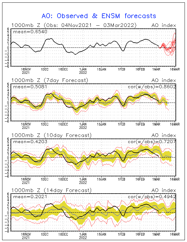
Indeed, we are currently in a period where the jet is weaker, and more wavelike features dominate weather patterns. This is very evident in the latest Arctic Oscillation (AO) Index, which has been negative for a while. A negative AO index indicates strong wave features, with potential for Arctic spills over the US, and anomalously warm Arctic temperatures. The pattern, however, is forecast to weaken in the following weeks, thus anomalous blocking patterns like the one seen above may become  less likely.


Thursday, September 13, 2012

Typhoon Sanba

Typhoon Sanba has become the object of attention lately, with its characteristic appearance of a robust tropical cyclones.  Below is an animation from NRL of the cyclone during the last couple of hours.


The cyclone strengthened rapidly while it passed an area of high ocean heat content, as seen below (image courtesy of CIMMS and RSMAS).  Although it has gained a lof of strength, reaching the Saffir-Simpson category 5 scale, it will likely not hold it for very long as it is leaving this area of high ocean heat toward one with cooler sea surface temperature.


As an additional sidenotem the cyclone is also dominating the upper-level divergence pattern in the form of velocity potential (divergence is the laplacian of velocity potential). In the plot below, yellow contours denote the velocity potential associated with large-scale upper level divergence, also associated with ascending motion. Green contours denote the opposite. Note the tight contours in the area where the storm lies.  The filled contours denote the upper level streamfunction. Tropical cyclones do not tend to project strongly in the rotation in the upper levels. The contours in that area are likely due to Rossby waves.
In a couple of days, Sanba might become a threat to some land areas in this region.We should keep close attention as this situation unfolds. 


Friday, January 6, 2012

About research money, outreach and people ...

Every once in a while I meet up with people I haven't seen in a while.  When you don't see people for a long time,  they seem to go through a similar routine of questions. Some of the questions include "What are you doing now?", "What's meteorology?" and the infamous "So meteorologists work with [insert something that's wrong but funny]?".  Last week I got asked if I worked with dinosaur bones! 

Sometimes you get thought-provoking questions, the ones that you keep thinking about long after the conversation is over.  For example, a couple of days ago I had another student ask me about funding. His questions were basically "How do you pay for school?", "Why are you getting this funding?" and "What is expected from you with this money. They look like pretty simple questions, and they are. The thing about them is that they make you think about the way that you are using your money,  what do you expect out of yourself, and so on. Naturally I told him about research assistantship, teaching assistantship and the many fellowship opportunities that are out there.  But then I started thinking "What do they want from me with that money?".

The fact is that they want you to do research with that money. Hopefully you will find interesting things, get some papers published, etc. All in all they just want you to add another drop to the cup of advancement of science. It is a topic that I keep mentioning in several blog posts.  In our field, one of the main goals is to improve weather prediction, so we can have better forecasts. 

Take for example what I do:  My research is focused on the MJO. While great progress has been made from it's discovery in the early 70's, there is still so much to get done.  It's complex behavior in the last couple of weeks has been discussed even among experts. All in all, we are still long ways to get a good grip over this big guy. 

It's erratic behavior has not been the only thing that's troublesome. Last year we had a good number of tropical cyclones that came to be, at least in part, due to the enhanced moisture and vorticity provided by the active MJO over the Indian Ocean/ Warm Pool region. Tropical cyclones Keila, Washi ,  Grant and Thane all were generated like this, to name a few.  Some of these storms caused significant damage to the areas they affected. In particular, Washi is responsible for more than a thousand deaths.

Images showing precipitation from TS Washi during the specified dates. The larger swath corresponds to TRMM's Microwave Imager (TMI)  while the smalle swath corresponds to the Precipitation Radar (PR).
These storms did plenty of damage, but what about other events. What about floods that come from prolonged rainfall, not associated with tropical cyclones. What about flash floods from convective precipitation? What about everything else that can be caused by anomalous weather. The truth is that we barely hear about these things. In fact, most people probably don't even know about the damage the tropical cyclones themselves did. The reality is that these events barely ever hit the headlines, and yet they happen on a year to year basis, claiming hundreds to thousands of lives. 

That's one of the reasons behind the heavy funding for research. If we could understand all this better, we could predict it better, hence reducing the likelihood of having a significant weather event claiming lives. But, is this really enough? The answer is inarguably no. 

There is a lot more to the safety of people than proper weather prediction. While it is great that nowadays we count with weather forecasts that are as easy to access as pressing your cellphone's button; it's pretty worthless is the reader has no idea how to interpret the forecast, even less if he/she doesn't know how to act to it. This is where outreaching comes into play.

Just as important as the science itself is spreading the knowledge to the public. But it is not something as simple as writing about it once and leaving it as is. It is a constant process. You have to let it be known with certain frequency, and be persistent about it. You also need enough facts and be convincing when you talk or else you might be shut down. It is a very difficult task. 

Back when I was in high school I was involved in a lot of community service. One of the things I got involved was doing a march against the abuse of elderlies. I directed the march and hundreds attended. It was one of the most fulfilling events of my life! In response to the march I got so much help from different people to help out with the, with people donating checks to wheelchairs. The next year I looked to follow up with a second march, or an event of similar magnitude. Because I was out of town for college I was unable to direct, so a new group emerged to make it happen. Communication between us was low, and the event never happen. That was it for the marches against elderly violence ...

Image from the march against elderly violence. 

That second march could have happened. It just needed more motivation, more persistence and the right attitude. This is what happens fairly often in many of lives situation, you bail on it thinking there's no solution when you can actually seek out an alternative. While this might be too simple with certain scenarios, like climate change, it is generally fairly true for many others. 

So are improvement and outreach all that we need? I don't think so. There's even more to all this than what I have mentioned. People's safety from weather, or other dangerous events depends just as much on each individual and the local government as it does on the other communities that work with it.  In the end it is a multifaceted task, which requires a drop of effort from many people. With the writing of this blog, I hope I do a little bit on the outreaching part. What about you?

Thank you for your time.

Ángel F. 


Saturday, December 31, 2011

[Res] Recapping the last active MJO

I want to start off this new year recapping the last 6-8 weeks of activity in the Indian Ocean area, where research is ongoing and activity has not even come close to ceasing. Just to show off how things have been, below is an visible image from Meteosat 7, provided by NRL. Here we see two active tropical cyclones: the now gone Cyclone Thane in the upper corner, and Cyclone Benilde in the lower portion of the image. 

Cyclone Thane in particular caused some significant damage to India's southeastern coast, uprooting several treen, causing power outages and claiming the lives of at least 42 people according to several news reports (Click here for some images of the aftermath of Thane). Below is a loop of IR images from Meteosat 7, showing the cyclones developing and moving westward, with Thane making landfall in the Indian coastline. 


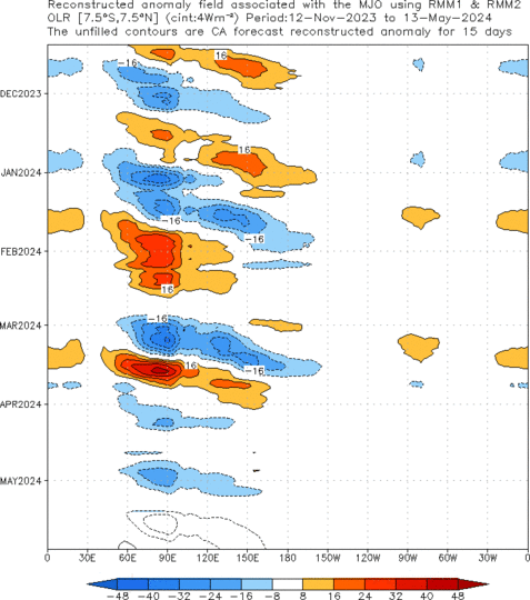
What is trully fascinating about these two cyclones is that their birth may largely be due to the rejuvenated (or newly formed) active MJO phase. In the image below, provided from NOAA's CPC, you can see the restart of OLR anomalies in the Maritime Continent sector. It's remarkable to see that, up to this moment, the anomalies associated with the MJO have had a similar pattern in OLR, particularly in their initiation part. I'm personally a little hesitant to say that this late December event is completely new, but from this picture, it almost looks like a new one started just further east than the other events. 


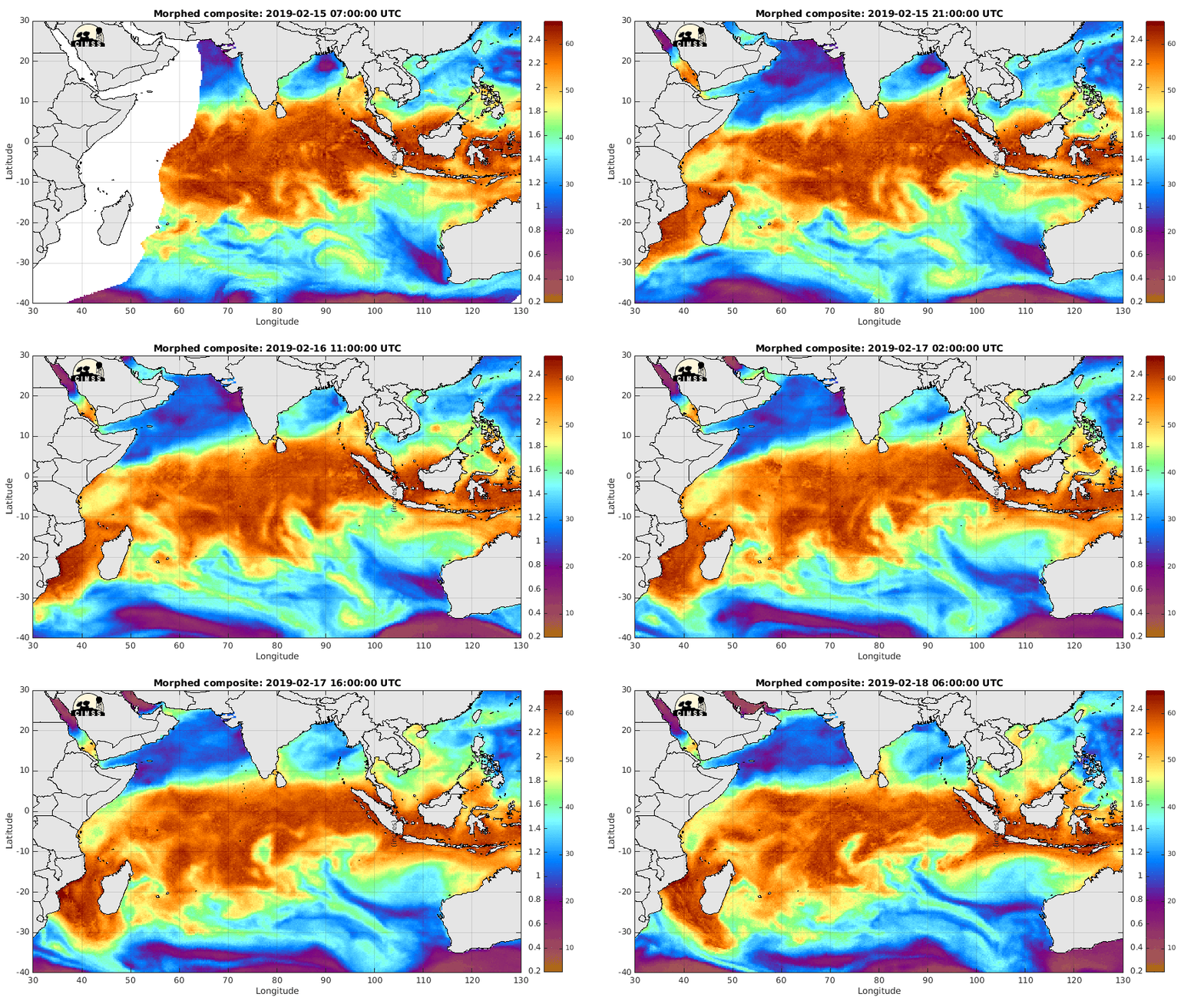
In the MIMIC-TWP loop below you can see both cyclones taking up moisture from the active MJO and from the apparent ITCZ in the southern Indian Ocean. It is also interesting to see some moisture from the remnants of Thane coming offshore on the western coast of India. Additionally, notice the dryer air mass creeping into the Maritime Continent.

The following loops shows a vertical cross section of moisture convergence over the Indian Ocean region for the last two months. When an MJO starts over the region convergence has much more vertical reach. Also, it seems to happen all over the region, making the method of initiation seem even more mysterious. 


The followig loop shows the 200 hPa moisture convergence and it's irrotational wind vectors for December 2011. Notice how when the December event strengthens, things start bubbling up in this region.  Overall things that makes one ponder about the dynamics of tropical instability

Wednesday, December 28, 2011

Nearing a close: 2011


I always love to make some sort of writing at the end of the year, mentioning some of the most memorable things. This year is no exception, it's been a special year. As 2010 marked a year of personal transformation, 2011 has been a year of continued growth.

In some ways it is also like every other year. You know, life has to go on, and it does every year. For me funny things have to happen to me every year, and this year was no exception. A few noteworthy things were:

1. I lost my keys and had broke into my own apartment.  I got in but still looked like a crook. I had some explaining to do to my neighbors after that!
2. Went snorkeling on the Florida Keys, got a cramp, everybody thought I was getting attacked by a shark.
3. Bought my 14th set of headphones (that I recall) since high school. This time I was smart enough to put a 2 year warranty on it. I finally learned!

Ok that's done with. Overall I feel like I have learned so much this year. I began research as a graduate student. That means that now I read scientific papers on a weekly basis. I am in no way near being an expert right now, but I have realized that there is just so much to learn in my field!!

Just look at the image below. Now normally one would just see the picture and say "Woah look at the clouds", or something like that. Nowadays I look at it and think "Wow that looks like complicated physics". You change like that. In a way you kinda become a little more insane, but not in a bad way.


In many ways I think this year by far has been two things. First of all I think it's been my most successful year professionally.  There is only one reason behind this: I just worked a little harder. I got my serious groove on and did an hour more of work per day. It has made a big difference. It doesn't mean I don't take breaks, I do, I am just better at organizing my time now (though I still get those moments in which I just sit on my exercise ball and do nothing).


Out of the things that 2011 has brought me, one is this obsession of constantly looking at what's going on in the Indian Ocean. A lot of the times it's kinda boring, but sometimes interesting things can brew, like on the loop below.


I guess that's just how it is sometimes. Just take the PhD comic below and substitute the question marks by the loop above, and you get my life on weekdays!


Well okay so maybe it's a little more than that. It's more like thinking about weather instruments, classes, research and donuts! Ok that's not true either! It's a pretty normal life actually, which is pretty much what I always wanted anyways.


Ok so I'm done with this post. Here's saying goodbye to what's probably been my happiest year so far (seriously). So it is with a little bit of sorrow that I say goodbye to it! Here's hoping for a great 2012!

Still merging science with wacky
Ángel F