
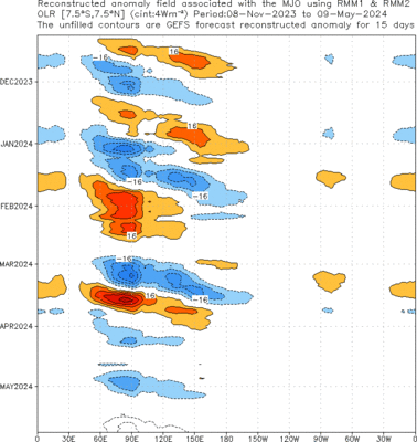
So we've had a nice fall season for MJO activity in the Indian Ocean, with a third one since September currently active over the Indian Ocean area (as can be seen in the reconstructed outgoing longwave radiation anomalies below) . There are differing forecasts on how this event will keep evolving, but it looks like the event will continue to be strong during the following week.

The latest loop from CIMMS MIMIC- Total Precipitable Water Vapor (TWP), shows very nicely the two gyres associated with the MJO, the area of westerly winds as well as the circulation of what now is tropical storm five (according to JTWC)! We can see as the moisture seems to migrate to the east, while the westerly winds almost appear to be fluxing drier air in. We can also observe TS 5 moving northwest as well as what appears to be the development of a new gyre close to the equator and 80 degrees of longitude.


This rotating feature (seen below), is almost looking similar to the other MJO gyres that were present previously, and is associated with a fairly large area of cloudiness. It will be interesting to see how this new circulation feature affects the dynamics prevailing over the area at this moment, which has been largely affected by TS 5 during the last couple of days.

No comments:
Post a Comment