Thought I'd make an update on yesterday's post on the state of the Indian Ocean and the MJO. It seems that convergence has become stronger in todays 12Z GFS run. Vertical motion has also begun to dominate a good area of the equatorial zone in the Indian Ocean, as seen in the figure below (see a loop of the latest couple of days)
 |
| Moisture convergence avergaged over 5 degrees S- 5 degrees N. Dashed lines indicate vertical motion. |
Moreover, the plot below (which I started compiling yesterday), is showing a slowly increasing trend in convergence over the region. While there aren't enough samples yet to clearly state if this is a real trend, it is definitely something to be on the lookout during the next couple of days.
 |
| Sum of positive moisture convergence for the last 7 GFS runs over the area covering from 40-100 degrees longitude and -15-15 degrees latitude |
Spotty regions of strong mid-tropospheric convergence is still visible in the region, with some amount of symmetry close to 60 degrees longitude. This is the area where the Rossby wave-like feature was present yesterday.
A closer look at the non-divergent winds and vorticity shows that this feature has become better defined. In fact, you do not have to decompose the winds any longer to observe this feature. There is also a fair amount of symmetry in the strength and position of the vorticity centers (Click here for a pdf version of image and here for a loop). The southern hemisphere portion still has stronger vorticity and more convective activity though. Energy fluxes from wave activity has also increased equatorial convection, making the double ITCZ pattern a little blurred. Additionally, westerly winds have greatly increased in area coverage over the last day over the whole domain, as compared to previous days. An active phase appears to have started!
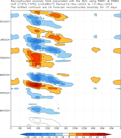
NOAA CPC analysis is saying that a new MJO has definitely initiated over the region, as shown below. This would make it the third MJO in a row, following the September one and the stronger mid-late October MJO.
 |
| Constructed Time-Longitude diagram of OLR anomalies from CPC |
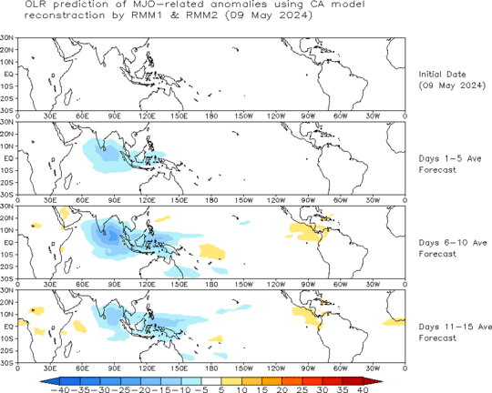
Current prediction is forecasting for this regime to remain over the Indian Ocean over the next two weeks. Let's see what happens. The folks over at the Maldives must be thrilled to see a second MJO over their area since the beginning of DYNAMO on October 1. This is great news and hopefully a lot of useful information about this event will come out of it!


No comments:
Post a Comment